学科简介
描述性物理海洋学以现场观测和遥感资料为基础,系统刻画海洋中各类物理要素的 空间分布与时间变化:温度、盐度、密度、溶解氧等水文要素的分布, 水团的划分与来源,大洋环流与中尺度涡的格局,海浪、潮汐、内波的形态与规律。
如果说动力物理海洋学回答"为什么",那么描述性物理海洋学回答的是"是什么样的"。 二者互为表里:观测描述是建立动力学理论的出发点,而理论反过来又指导我们如何设计观测、检验结论。
核心知识要点
核心概念与知识点解析,点击条目即可展开详细内容
EOF(经验正交函数) Empirical Orthogonal Functions
定义与本质
Empirical Orthogonal Functions(EOF,经验正交函数)是气象、海洋、气候等地球科学中最常用的时空数据降维和模态分解方法。它本质上是对包含时间和空间维度的观测资料进行线性正交变换,将其分解成若干彼此正交的“空间型”(Spatial Patterns)和对应的“时间系数”(Time Coefficients / Principal Components, PCs)。
数学原理
在数学上,EOF 分解等价于对原始时空数据矩阵的协方差矩阵进行特征值分解(或对数据矩阵进行奇异值分解 SVD)。
- 空间型(特征向量):代表数据在空间上协同变化的典型结构。第一空间型(EOF1)解释了数据集中最多的方差,第二空间型(EOF2)在与 EOF1 正交的约束下解释剩余最多的方差,以此类推。
- 时间系数(主成分):表示对应的空间型随时间的演变强度(振幅与相位)。
- 方差贡献率(特征值):表示该模态在总方差中所占的百分比。通常前几个模态就能解释总方差的绝大部分(如 70%~90%),从而实现大幅降维。
物理意义
- 空间上:EOF 空间型揭示了哪些区域的海温、盐度或流场倾向于“同步”发生变化(正相关),哪些区域呈现相反的“跷跷板”式变化(负相关)。
- 时间上:时间系数直观展示了这种空间型随时间增强、减弱或位相反转的过程。
典型应用与局限
- 优势:无需预设任何物理模型,直接从数据中提取主导模态;能有效压缩数据量,提取信号。
- 局限:EOF 是纯数学的线性分解,分解出的空间型未必直接对应某个单一的物理过程,可能会出现“模态混合”现象。因此,在物理解释时通常需要结合动力学理论加以验证。
- 应用实例:太平洋海表温度的 EOF1 通常对应厄尔尼诺-南方涛动(ENSO)的空间结构;海平面气压的 EOF1 常用来表征北大西洋涛动(NAO)。
地转流 Geostrophic Flow
定义与本质
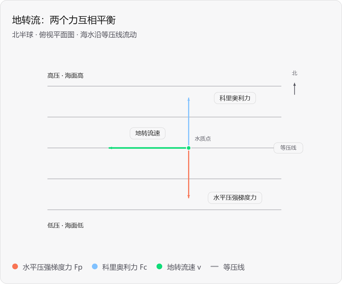
地转流(Geostrophic Flow)是指在忽略摩擦力的情况下,海洋中水平压强梯度力与科里奥利力达到平衡时所产生的稳态流动。这是大尺度海洋内部环流最基本的动力平衡状态。
数学表达与平衡关系
地转平衡的基本方程为:科里奥利力 = 水平压强梯度力。在直角坐标系中,其水平分量可表示为:
f × Vg = 1ρ ∇p
其分量形式为:
ug = - 1f ρ ∂p∂y , vg = 1f ρ ∂p∂x
其中,f 为科里奥利参数(f = 2Ωsinφ),ρ 为海水密度,p 为压强。由公式可知,地转流速的大小与水平压强梯度力(或海面坡度)成正比,与科里奥利参数及密度成反比(即纬度越高、密度越小,流速越大)。
流向特性(非常重要)
- 在北半球(f > 0):地转流方向偏向压强梯度力的右侧(即流向高压的右侧,低压的左侧)。
- 在南半球(f < 0):地转流方向偏向压强梯度力的左侧(即流向高压的左侧,低压的右侧)。
- 因此,地转流总是沿着等压线(等海面高度线)流动,在无摩擦大洋内部,基本没有跨等压线的质量输送。
适用条件与局限性
- 适用条件:大尺度(空间尺度通常大于 100 km)、中高纬度(赤道附近 f ≈ 0,不适用)、长周期(数天至数月以上)、远离强摩擦边界(如大洋内区)。
- 不适用情况:赤道地区(需考虑赤道波动力学)、近岸浅水区、强流区(如西边界流,摩擦力不可忽略)、短周期运动(如潮汐、高频内波)。
实际意义
地转平衡是现代物理海洋学的基石。它使得我们能够通过观测海水的密度场(温盐分布)来反推海流场(即动力计算方法)。大洋环流(如黑潮、湾流、南极绕极流的主体)在远离边界处,均近似满足地转平衡。
湾流剖面图:怎样判断流向? Gulf Stream Profile: How to determine flow direction?
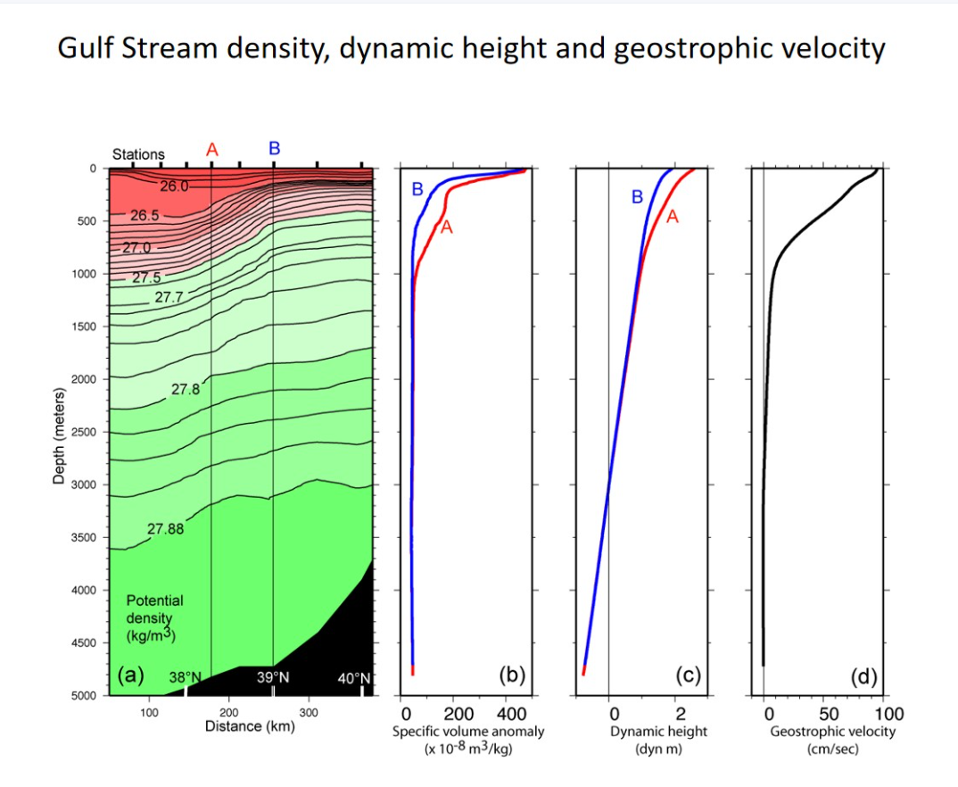
图(a)密度剖面图:图(a)横轴从左侧约37°N到右侧40°N,因此左侧偏南、右侧偏北;A在B的南侧。在A和B之间,等密度线发生了极其剧烈的向下倾斜(倾斜的锋面)。这种密度的巨大水平差异(A站上方轻水堆积,B站重水偏多)是产生强大动力高度的直接原因。
图(b) 密度与比容异常(海水实际比容与标准状态下比容的差值):海水的上层A侧同一深度的海水较轻,比容异常较大;B侧较密,比容异常较小。等密度线向北(向右)抬升,显示明显的水平密度差。
图(c) 动力高度与压强梯度力:在相同参考压力下向上积分比容异常,A上层水体的动力高度高于B。因此上层动力高度由南向北减小,对应向北的水平压强梯度力。
图(d) 流速结构:表层流速极快:表层流速达到约100 cm/s(即1米/秒,约2节),这体现了墨西哥湾流作为西部边界流的强劲特征。流速随深度迅速衰减:流速在几百米内迅速下降,在约1500-2000米深处趋近于0(这也是计算地转流时假定的“无运动面”)。
流向结论(核心推导):
北半球 f > 0,取 x 向东、y 向北,地转流公式为:
ug = − 1f ∂D∂y
其中 D 为动力位势异常。由 ∂D/∂y < 0 得到 ug > 0:在北半球科氏力向右偏转的作用下,水流沿着等密度线陡峭的锋面,向图片内急速流动。这就完美解释了为什么墨西哥湾流具有“流速快、流幅窄、深度深”的特点。。
重点名词解释
- 离心力 Centrifugal Force
- 在随地球自转的旋转参考系中引入的惯性力(视示力),并非真实物理相互作用。 海水随地球自转所受单位质量离心力为 fc = Ω²r 方向垂直于自转轴向外;它与万有引力合成为重力。
- 科里奥利力 Coriolis Force
- 地球自转导致在旋转参考系中运动的物体产生的惯性力(视示力)。 其大小为 f = 2Ω sinφ(φ为纬度),方向垂直于物体运动方向(北半球向右,南半球向左)。 科氏力只改变运动方向,不改变运动速度大小,随纬度增大而增大。
- 惯性运动 Inertial Motion
- 海洋中仅考虑科里奥利力作用(忽略压强梯度力、摩擦力和外力)的水平运动。 水质点轨迹为圆形的惯性圆,北半球顺时针旋转,南半球逆时针旋转。 其周期为 T = 2π / f,在赤道处无穷大,两极处最小。
- 地转平衡 Geostrophic Balance
- 水平压强梯度力与科里奥利力达到平衡的状态,适用于中高纬度大尺度、无摩擦的海洋内部运动。 地转流沿着等压线流动:北半球流向高压在右侧,南半球流向高压在左侧。 这种平衡是描述大洋环流的基础。
- 热成风 Thermal Wind
- 地转流随深度(或压强)的变化与海水水平密度梯度之间的关系,是地转平衡与静力平衡结合的产物。 其核心结论是:水平温度(密度)梯度越大,地转流的垂向切变就越强。 由于暖水区(轻)与冷水区(重)的差异,上层海流相对于深层通常表现出更强的切变。
- 动力高度 Dynamic Height
- 海洋学中用于表示等压面相对于某一参考面(通常取海面)起伏的物理量。 它由海水比容(或密度)的垂向积分得到,直接反映海面的动力地形。 动力高度差的分布与地转流密切相关,常用于计算海洋表层与次表层的地转流场。
- 埃克曼层 Ekman Layer
- 海洋表面(或底部)受风应力(或底摩擦)与科里奥利力共同作用形成的边界层。 在表层风生埃克曼层中,流速随深度呈螺旋状衰减并偏转(埃克曼螺线)。 净水体输送(埃克曼输送)在北半球垂直于风向右侧,南半球向左。
课程习题与解答
Q1 风生混合的典型混合层深度是多少?若由冷却驱动,其深度能达到多少?How deep is a typical mixed layer if mixed by wind? How deep can it reach if driven by cooling?
【中文】风生混合通常为数百米量级;冷却驱动的对流混合可达千米量级,在极高纬度深对流区甚至可达数千米。
【English】The wind mixing is typically on the order of hundreds of meters; the cooling-driven convection mixing can reach kilometer-scale, and in extremely high-latitude deep convection areas, it can even reach several kilometers.
Q2 北太平洋副热带和亚极地地区典型的温度和盐度垂直剖面是什么样的?What are the typical vertical temperature and salinity profiles in the subtropical and subpolar regions of the North Pacific?
【中文】在北太平洋副热带地区,表层海水温暖且盐度较高。温度通过强温跃层迅速下降,盐度通常在表层达到最大值,而在深层水或中层达到最低值。在北太平洋靠近极地的区域,表层海水更冷、更淡;温跃层较弱,或者可能存在深层温度逆增现象。盐度通常随深度增加,在明显的盐度跃层中,盐度上升,有助于维持水体的层结结构。
【English】In the subtropical region of the North Pacific Ocean, the surface seawater is warm and has a relatively high salinity. The temperature drops rapidly through a strong thermocline, and the salinity usually reaches its maximum at the surface while it is at its lowest in the deep water or middle layer. In the North Pacific near the polar regions, the surface seawater is colder and more freshwater; the thermocline is weaker, or there may be a deep temperature inversion phenomenon. Salinity generally increases with depth, and in the obvious salinity transition zone, it rises, which helps maintain the stratified structure of the water body.
Q3 海洋中净蒸发的主导区域有哪些?What are the dominant regions of net evaporation in the ocean?
【中文】海洋中净蒸发主导的区域主要受大气环流控制,集中在副热带高压带、信风带以及一些蒸发强烈的半封闭边缘海。总体而言,海洋净蒸发的主导区域呈纬向带状分布,核心位于南北半球的副热带海洋,最典型的是副热带北大西洋、红海、波斯湾和地中海。
【English】The regions where net evaporation is dominant in the ocean are mainly controlled by the atmospheric circulation and are concentrated in the subtropical high-pressure belt, the trade wind belt, and some semi-enclosed marginal seas with strong evaporation. In general, the dominant areas of ocean net evaporation are in a latitudinal band pattern, with the core located in the subtropical oceans of the north and south, and the most typical ones are the subtropical North Atlantic Ocean, the Red Sea, the Persian Gulf, and the Mediterranean Sea.
Q4 混合层热量收支的关键组成部分有哪些?What are the key components of the Mixed Layer heat budget.
【中文】特定水体的热量收支:Qt = Qs + Qb + Qe = Qh + Qv,其中Qt是水体获得或损失热量的总速率。
- Qs:通过海面流入的太阳能速率(短波辐射)。
- Qb:海洋以长波辐射向大气和太空散失热量的净速率(黑体辐射)。
- Qe:通过蒸发/凝结获得/损失热量的速率(潜热通量)。
- Qh:通过传导通过海面获得/损失热量的速率(感热通量)。
- Qv:水体因洋流获得/损失热量的速率(平流项)。
【English】The heat budget for a particular body of water: Qt = Qs + Qb + Qe = Qh + Qv, where Qt is the total rate of gain or loss of heat of the body of water.
- Qs: Rate of inflow of solar energy through the sea surface (short-wave radiation).
- Qb: Net rate of heat loss by the sea as long-wave radiation to the atmosphere and space (black radiation).
- Qe: Rate of heat loss/gain by evaporation/condensation (the latent heat flux).
- Qh: Rate of heat loss/gain through the sea surface by conduction (the sensible heat flux).
- Qv: Rate of heat loss/gain by a water body due to currents (the advective term).
Q5 北大西洋的平均盐度比太平洋高还是低?为什么?Is the North Atlantic Ocean saltier or fresher on average than the Pacific? Why?
【中文】北大西洋的平均盐度高于北太平洋。主要原因是,大西洋存在净蒸发,太平洋存在净降水,再加上来自地中海的高盐输入和北大西洋深层水的形成,共同维持了两大洋之间的盐度差异。
【English】The North Atlantic is saltier on average than the North Pacific. The main reason is that the Atlantic Ocean has net evaporation, the Pacific Ocean has net precipitation, combined with the high-salt input from the Mediterranean Sea and the formation of deep water in the North Atlantic, which together maintain the salinity difference between the two oceans.
Q6 哪些海域的夏季到冬季变化差异较大?哪些海域的季节性变化最小?What regions of the ocean are characterized by large differences from summer to winter? What regions have the least seasonal variability?
【中文】最大的季节性变化出现在中纬度西边界流、边缘海、浅海以及北半球的北印度洋季风区;最小的季节性变化出现在热带暖池。
【English】The greatest seasonal variations are observed in the mid-latitude western boundary currents, marginal seas, shallow seas and the North Indian Ocean monsoon region of the Northern Hemisphere; the smallest seasonal changes are found in the tropical warm pool.
Q7 请描述维持温跃层的两个过程。Please describe the two processes that maintain the thermocline.
【中文】1. 表面浮力输入与稳定层结
海面加热使表层海水变暖变轻;降水、融冰等淡水输入降低了表层水的盐度和密度。下方深层水相对寒冷且沉重,因此密度随深度增加,形成稳定层结。这种稳定层结抑制了垂直混合,使温暖的表层水难以与寒冷的深层水交换,从而使温跃层得以存在。
2. 风生埃克曼抽吸与垂向平流-扩散平衡
风应力旋度驱动埃克曼抽吸:在副热带,表层水辐聚下沉,导致温跃层加深;在热带和部分高纬度地区,埃克曼辐散引起上升流,将冷水带到表层,导致温跃层抬升。同时,在经典的一维温跃层理论中,冷水的缓慢垂直平流和热量的向下湍流扩散相互平衡,维持了温跃层的温度和深度结构。
【English】1. Surface buoyancy input and stable stratification
Heating at the sea surface causes the surface seawater to warm and become lighter; freshwater inputs such as precipitation and melting ice reduce the salinity and density of the surface water. The deeper water below is relatively cold and heavy, so the density increases with depth, forming a stable stratification. This stable stratification inhibits vertical mixing, making it difficult for the warm surface water to exchange with the cold deep water, allowing the thermocline to exist.
2. Wind-generated Ekman suction and vertical advection-diffusion equilibrium
Wind stress curl drives Ekman suction: in the subtropics, the surface water converges and sinks, causing the thermocline to deepen; in the tropics and some high latitudes, Ekman divergence causes upwelling, bringing cold water to the surface, causing the thermocline to rise. At the same time, in the classic one-dimensional thermocline theory, the slow vertical advection of cold water and the downward turbulent diffusion of heat balance each other, maintaining the temperature and depth structure of the thermocline.
Q8 分别是什么因素决定了热量收支项Qs、Qb、Qe和Qh?明确每个项中各因素的重要性。What factors determine the heat budget terms, Qs, Qb, Qe and Qh, respectively? Make clear the importance of each factor of each term.
【中文】
- Qs:通过海面流入的太阳能速率(短波辐射)。太阳高度角(纬度、季节和时间)和云量尤为重要。
- Qb:海洋以长波辐射向大气和太空散失热量的净速率(黑体辐射)。海表温度影响海洋表面的向上辐射;云量、大气温度和水汽含量影响向下辐射。
- Qe:通过蒸发/凝结获得/损失热量的速率(潜热通量)。风速与海面饱和比湿及海面附近空气比湿的差值是最直接的控制因素。
- Qh:通过传导通过海面获得/损失热量的速率(感热通量)。海气温差和风速是主要因素。
【English】
- Qs: Rate of inflow of solar energy through the sea surface (short-wave radiation). The solar altitude angle (latitude, season and time of day) and cloud cover are particularly important.
- Qb: Net rate of heat loss by the sea as long-wave radiation to the atmosphere and space (black radiation). SST affects the upward radiation of the ocean surface; cloud cover, atmospheric temperature and water vapor content affect downward radiation.
- Qe: Rate of heat loss/gain by evaporation/condensation (the latent heat flux). The difference between wind speed and sea surface saturated specific humidity and the specific humidity of the air near the sea surface is the direct controlling factor.
- Qh: Rate of heat loss/gain through the sea surface by conduction (the sensible heat flux). The temperature difference between the sea and the air and wind speed are the main factors.
Q9 这四个项的量级范围是多少?对于每个项,请指出最大值和最小值中心的位置和数值。What are the ranges of the magnitude of the four terms? For each term, please specify the location and value of the maximum and minimum center.
【中文】
- Qs:0至超过200 W/m²。最大值(超过200 W/m²)主要位于南半球副热带地区。最小值(0-50 W/m²)位于极地周边海域。
- Qb:-100至0 W/m²。最大值(-25至0 W/m²)位于赤道附近的热带多雨湿润带。最小值(-100至-75 W/m²)位于副热带干燥海域。
- Qe:-200至0 W/m²。最大值(-50至0 W/m²)位于大部分高纬度海域。最小值(-200至-150 W/m²)位于蒸发强烈的副热带和热带地区。
- Qh:-60至15 W/m²。最大值(0至15 W/m²)位于南大洋局部区域。最小值(-200至-150 W/m²)位于墨西哥湾流和黑潮附近。
【English】
- Qs: 0 to more than 200 W/m². The maximum values (more than 200 W/m²) are mainly located in the subtropical regions of the Southern Hemisphere. The minimum (0-50 W/m²) is located in the surrounding seas of the polar regions.
- Qb: -100 to 0 W/m². The maximum value (-25 to 0 W/m²) is located in the tropical rainy and humid zone near the equator. The minimum value (-100 to -75 W/m²) is located in the dry waters of the subtropical zone.
- Qe: -200 to 0 W/m². The maximum value (-50 to 0 W/m²) is located in most of the high-latitude seas. The minimum value (-200 to -150 W/m²) is located in the subtropical and tropical areas with intense evaporation.
- Qh: -60 to 15 W/m². The maximum value (0 to 15 W/m²) is located in a local area of the Southern Ocean. The minimum value (-200 to -150 W/m²) is located near the Gulf Stream and the Kuroshio Current.
Q10 计算北极、30°N、赤道和南极的惯性振荡周期。Work out the period of inertial oscillations at the north pole, 30N, equator, and south pole.
【中文】惯性振荡的周期公式为:
T = 2πf = 12sinφ (小时)
其中 f = 2Ωsinφ 为科里奥利参数,φ 为纬度。代入各纬度计算如下:
- 北极 (90°N):T = 12 / sin(90°) = 12小时
- 30°N:T = 12 / sin(30°) = 24小时
- 赤道 (0°):f = 0,T → 无穷大(赤道上不存在惯性振荡)
- 南极 (90°S):T = 12 / |sin(-90°)| = 12小时
注:惯性周期在两极最短(12小时),随纬度降低而变长,赤道处趋于无穷。
【English】The period formula for inertial oscillations is:
T = 2πf = 12sinφ (hours)
Where f = 2Ωsinφ is the Coriolis parameter, and φ is latitude. Substituting for each latitude:
- North Pole (90°N): T = 12 / sin(90°) = 12 hours
- 30°N: T = 12 / sin(30°) = 24 hours
- Equator (0°): f = 0, T → infinity (no inertial oscillations at the equator)
- South Pole (90°S): T = 12 / |sin(-90°)| = 12 hours
Note: The inertial period is shortest at the poles (12 hours), lengthens as latitude decreases, and approaches infinity at the equator.
Q11 在地转流中,科里奥利力相对于压强梯度力的方向是什么?相对于速度的方向又是什么?In geostrophic flow, what direction is the Coriolis force in relation to the pressure gradient force? What direction is it in relation to the velocity?
【中文】与压强梯度力的关系:在地转平衡中,科里奥利力与水平压强梯度力大小相等、方向相反(相差180°)。正是这种平衡使得水体能够沿着等压线运动。
与速度的关系:科里奥利力始终垂直于速度方向。在北半球,科里奥利力指向运动方向的右侧(90°);在南半球,则指向运动方向的左侧(90°)。因此,科里奥利力只改变运动方向,不改变速度大小。
【English】Relationship with pressure gradient force: In geostrophic balance, the Coriolis force is equal in magnitude and opposite in direction (180° apart) to the horizontal pressure gradient force. It is this balance that allows water bodies to move along isobars.
Relationship with velocity: The Coriolis force is always perpendicular to the velocity direction. In the Northern Hemisphere, it points to the right of the motion (90°); in the Southern Hemisphere, it points to the left (90°). Therefore, the Coriolis force only changes the direction of motion, not the speed.
Q12 什么是“无运动面”?为什么在同类计算中,“已知运动面”会是更好的选择?(在给定密度分布和地转假设下,我们实际上能计算出速度结构的什么信息?)What is a "level of no motion"? Why would a "level of known motion" be a better choice for the same kind of calculation? (What can we actually compute about the velocity structure given the density distribution and an assumption of geostrophy?)
【中文】无运动面(Level of No Motion):指在计算地转流时,假设存在一个深度,使得该深度上的地转流速为零(即作为计算速度的参考面)。这是一种传统但往往不符合实际的假设。
为什么“已知运动面”更好:“无运动面”仅仅是一个为了方便计算而人为设定的假设,真实海洋中通常并不存在绝对静止的水层。而“已知运动面”利用直接观测数据(如ADCP测流、漂流浮标等)来确定某一深度上的真实流速,以此作为参考面,可以更准确地计算出绝对地转流速,避免了无运动面假设带来的误差。
仅凭密度分布和地转假设能计算出什么:根据密度分布和地转平衡,我们只能计算出地转流的垂向切变(相对速度),即不同深度之间的流速差。要得到绝对流速,必须额外引入一个参考速度(如已知运动面或利用绝对地转流方法)。
【English】Level of No Motion: Refers to a depth assumed to have zero geostrophic velocity when calculating geostrophic currents (i.e., used as a reference level). This is a traditional assumption that often does not conform to reality.
Why "level of known motion" is better: The "level of no motion" is merely an artificial assumption for calculation convenience; an absolutely motionless layer generally does not exist in the real ocean. A "level of known motion" utilizes direct observational data (e.g., ADCP current measurements, drifting buoys) to determine the true velocity at a certain depth. Using this as a reference level allows for more accurate calculation of absolute geostrophic velocity, avoiding errors from the no-motion assumption.
What can be computed with only density distribution and geostrophy: Based on density distribution and geostrophic balance, we can only compute the vertical shear (relative velocity) of geostrophic currents, i.e., the velocity difference between different depths. To obtain absolute velocity, an additional reference velocity must be introduced (e.g., known motion level or absolute geostrophic methods).
Q13 列举位涡的三个贡献因子。Name the three contributing factors to potential vorticity.
【中文】位涡(Potential Vorticity, PV)的表达式通常为:
PV = f + ζH
其三个贡献因子为:
- 行星涡度(f):由地球自转产生,等于 2Ωsinφ,随纬度变化。
- 相对涡度(ζ):由水体本身的旋转运动(切变和曲率)产生。
- 流体深度/层结厚度(H):流体柱的垂直厚度,在连续层结中与密度层结相关(如等密度面之间的距离)。
根据位涡守恒原理,当流体柱被拉伸或压缩(H变化)时,必须通过改变相对涡度(ζ)或移动至不同纬度(改变f)来保持PV守恒。
【English】The expression for Potential Vorticity (PV) is typically:
PV = f + ζH
Its three contributing factors are:
- Planetary vorticity (f): Generated by Earth's rotation, equal to 2Ωsinφ, varying with latitude.
- Relative vorticity (ζ): Generated by the rotational motion (shear and curvature) of the water body itself.
- Fluid depth/stratification thickness (H): The vertical thickness of the fluid column, related to density stratification in continuous stratification (e.g., distance between isopycnal surfaces).
According to potential vorticity conservation, when a fluid column is stretched or compressed (H changes), it must change relative vorticity (ζ) or move to a different latitude (changing f) to maintain PV conservation.
Q14 埃克曼抽吸如何与斯维尔德鲁普内区流相联系?请使用位涡论证进行解释。How does Ekman pumping connect to the Sverdrup interior flow? Explain using potential vorticity arguments.
【中文】埃克曼抽吸与斯维尔德鲁普流的联系:风应力旋度驱动埃克曼层产生辐聚或辐散,从而在埃克曼层底部产生垂向速度(即埃克曼抽吸,wE)。这个垂向速度不仅驱动了表层水体的运动,还通过质量守恒和位涡守恒,控制了深层大洋内区的斯维尔德鲁普流。
位涡论证:
- 在海洋内区(无摩擦、准地转),位涡守恒:PV = f + ζH。
- 埃克曼抽吸导致内区流体柱底部产生垂向运动,这会引起流体柱的拉伸或压缩(即H发生变化)。
- 为了维持位涡守恒,流体柱必须通过改变纬度(即产生经向运动v)来改变行星涡度f,或者改变相对涡度ζ。在大尺度大洋内区,ζ远小于f,因此主要是经向运动改变f来平衡。
- 由此推导出的斯维尔德鲁普平衡关系为:βV = curl(τ)ρ(其中β = df/dy,V为经向输送,τ为风应力)。
这说明:风应力旋度(通过埃克曼抽吸改变H)直接决定了内区流体的经向运动(改变f),从而维持了斯维尔德鲁普流。埃克曼抽吸是连接表面风场与深层内区环流的关键动力纽带。
【English】Connection between Ekman pumping and Sverdrup flow: Wind stress curl drives convergence or divergence in the Ekman layer, generating a vertical velocity at the base of the Ekman layer (i.e., Ekman pumping, wE). This vertical velocity not only drives surface water movement but also controls the Sverdrup interior flow through mass conservation and potential vorticity conservation.
Potential vorticity argument:
- In the ocean interior (frictionless, quasi-geostrophic), potential vorticity is conserved: PV = f + ζH.
- Ekman pumping causes vertical motion at the base of the interior fluid column, which causes stretching or compression of the fluid column (i.e., H changes).
- To maintain PV conservation, the fluid column must change latitude (i.e., generate meridional motion v) to change planetary vorticity f, or change relative vorticity ζ. In the large-scale ocean interior, ζ is much smaller than f, so meridional motion changing f is the primary balance.
- The resulting Sverdrup balance relationship is: βV = curl(τ)ρ (where β = df/dy, V is meridional transport, and τ is wind stress).
This indicates that wind stress curl (changing H through Ekman pumping) directly determines the meridional motion (changing f) of the interior fluid, thereby maintaining the Sverdrup flow. Ekman pumping is the key dynamic link between the surface wind field and the deep interior circulation.
出门票
每一堂课的出门票,记录课程相关内容
1 出门票
待补充
2 出门票
待补充
3 出门票
待补充
4 出门票
待补充
5 出门票
待补充
6 出门票
地转流(Geostrophic Flow)是指在忽略摩擦力的情况下,海洋中水平压强梯度力与科里奥利力达到平衡时所产生的稳态流动。这是大尺度海洋内部环流最基本的动力平衡状态。
Ekman理论:
1.Ekman螺旋:风是怎么吹动海水的?
如果你用一块木板去拨动水面,水会直接顺着风向流。但在大洋中,因为地球自转(科氏力),情况完全不同:
表层海水:受到风应力驱动,但立刻受到科氏力的偏转(北半球向右,南半球向左)。
次表层海水:由于海水内部存在摩擦力(粘性),表层水流会拖动下层水,但力量减弱。
结果:越往深处,水流速度越慢,且偏转角度越大。如果把不同深度的海流箭头连起来,你会发现它们形成一个像弹簧一样的螺旋结构,这就是著名的艾克曼螺旋。
2.Ekman输运:90度的奇迹
虽然每一层海水的流向都不一样,但如果我们把整个“艾克曼层”(通常指表层几十米到上百米深)的水体加起来求总和(净输送),会发生一个惊人的结果:
北半球:净水体输送方向总是位于风向的正右侧90度。
南半球:净水体输送方向总是位于风向的正左侧90度。
举个极端例子:在北半球,如果风一直向南吹,表层海水会偏向西南,深处偏得更多,但总体算下来,绝大部分的海水其实是向东(向风向的右侧)流走的。
3. Ekman抽吸:上下运动的关键
当风吹拂广阔的海面时,由于风的方向和大小在不同区域不一样,会导致水体的“辐聚”或“辐散”:
辐聚(Convergence):如果四周的风把水都往中心吹(例如副热带环流中心),那么多余的水只能往下沉,这叫艾克曼抽吸(下降流)。
辐散(Divergence):如果风把中心的水往外吹(例如赤道或副极地),底下的水就得往上涌,这叫艾克曼抽吸(上升流)。

Sverdrup:海水表面的风向,信风由东向西吹,西风带由西向东吹。风吹过海水表面时,海水在流动时受到顺时针方向的柯氏力的作用(北半球),表面产生埃克曼输运。因此在环流的中部,当表层海水在环流中心不断汇聚时,多余的水只能向下走;在环流的边缘,为补充环流形成上升流。下层海水由于位涡守恒:(f+ζ)/H=c,以及f=2Ωsinφ,为保持平衡(水柱被压缩或膨胀),因此需要改变sinφ这一项,下层海水向低纬度(赤道方向流动)。